Built in Sydney · three technologies live on the street today
Our GPS Audio Technology
One engine, three genuinely different jobs. What changes between them is not the content — it is the geometry: how fast the listener is moving, how tightly the trigger zones have to sit, and how early the guide has to start talking. All three are web pages: no app store, no download, no install, nothing to update. Designed, written and operated by Antratel Pty Ltd, licensed Sydney guides since 2006.
1 · Light Rail
The passenger sits still and the vehicle does the moving. Triggers ride the line: the approaching stop is announced, then the story of whatever is passing the window right now, with the podcast covering the run in between. Fixed route, fixed stops, tram speed — and a QR poster on the platform instead of a ticket.
2 · Events on foot
No route at all. A festival is a dense field of geofences in a few hundred metres, at night, in a crowd — the visitor wanders in any order and each artwork unlocks itself when they step into its zone. Zone size is drawn per installation, and the whole content set is swapped between editions.
3 · Walk, bicycle or car
One guide that follows the listener’s own speed. On foot it works out which way you face and fires at the right doorway; at road speed it decides early, speaks once and tells you which window to look through — through the car speakers over Bluetooth.
Registered NSW Government supplier. Antratel Pty Limited (ABN 24 122 328 492) is listed on the NSW Government’s buy.nsw supplier marketplace — see our supplier profile — under Information and technology (solution design and development, software licensing and support) and Marketing and advertising.
SMENSW-based businessRegistered for faster payments
Of the 87,000+ suppliers registered on buy.nsw, as at August 2026 we are not aware of another one delivering GPS-triggered audio guides that run in the browser with no app install. The platform is built in-house and held as our own copyright-protected work — not a licensed third-party app — so councils, transport operators and agencies can engage us through existing procurement channels.
What the engine actually does
The same core runs under all three technologies. Only the point database, the trigger geometry and the audio change.
🧭 Orientation — it knows which way you face
Path projection and bearing detection let the guide say "look on your right" or "look on your left" instead of a vague "attraction ahead". The map can rotate to Heading-Up, so left on the screen is your actual left — no mental flipping at intersections.
🎧 It never goes silent
A continuous Australia podcast plays in the gaps between points. When a landmark comes into range the podcast steps aside, the landmark story plays with its direction cue, then the podcast resumes from the exact second it left off — across sessions, days and separate trips.
⏮ A player built for a moving listener
There is no scrubber to aim at on a bumpy road. ⏮ and ⏭ jump whole paragraphs, not fifteen seconds: every file ships with a map of its own sentence boundaries, so a skip always lands at the start of a thought. Skip back from the beginning of one podcast episode and you continue into the last paragraph of the previous one — eighteen episodes behave like a single continuous file. Speed 1× / 1.5× / 2× / 3×, volume and day-night sit one tap away, and every menu opens downwards so it never covers the map.
☰ Interest groups — the visitor picks the tour
One tick-box panel filters the whole route: Historical, Nature & Beach, Shopping, Wildlife, Photo Sights, Bicycle trails. The list re-sorts and re-numbers itself, so two people on the same street can be running two different tours.
🕑 Speed-adaptive triggers
Trigger zones are computed from your real movement speed: tight and directional for walkers, wide and early for a car or a tram. The same point database serves 4 km/h and 60 km/h without a separate build.
📱 Nothing to install
It is a web page. Scan a QR code or open a link and the tour starts. No App Store, no account, no updates, no 200 MB download on hotel Wi-Fi — and no app review process standing between you and a content change.
💬 Written by a guide, voiced by AI
Every word is written by a Sydney guide with 20 years on the road and voiced with an AI model of his own voice — which is how one guide can cover 150+ points and still sound consistent from the first stop to the last.
Technology 1 — Public transport
Sydney Light Rail — a free audio guide that rides with the tram
A QR poster at the stop, a phone, headphones — and the tram becomes a guided tour. The guide tracks the vehicle along the line, announces each stop, and tells the story of what is passing the window right now. Between stops the podcast keeps talking, so a 30-minute ride is never dead time.
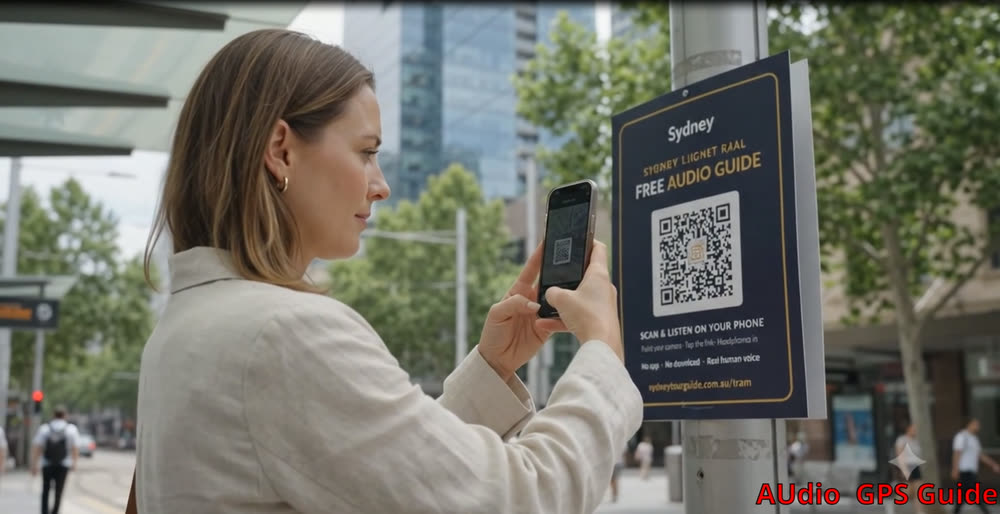 The poster is the whole distribution channel. A rider points the camera at the QR on the platform and is listening about twenty seconds later — no App Store detour, no account, no 200 MB download on station Wi-Fi. For an operator that removes the step where most transit apps lose their audience: there is nothing to install, so adoption is a decision made in the moment of waiting for the tram.
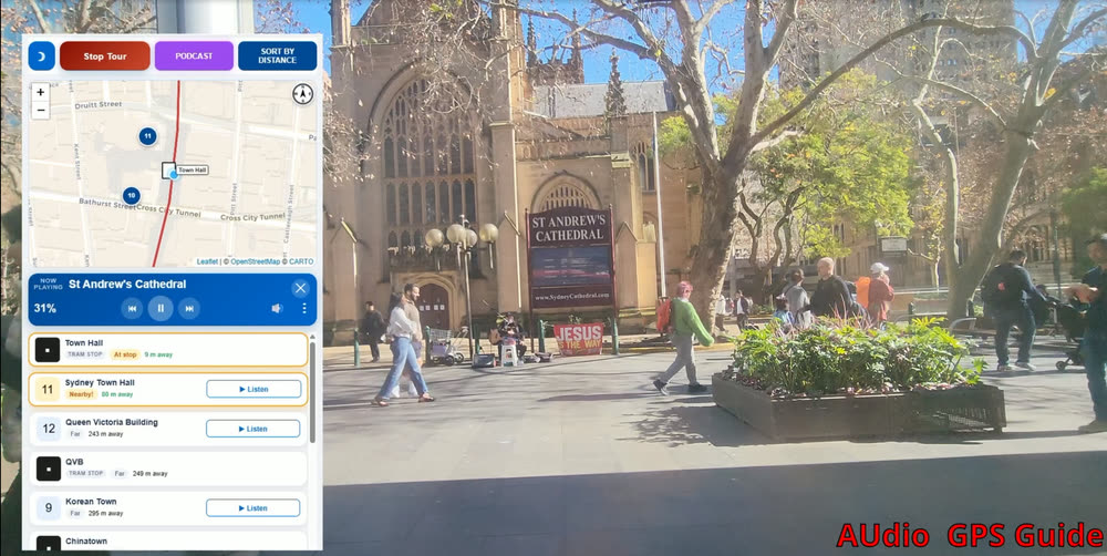 Riding past St Andrew’s Cathedral. The engine knows where the vehicle sits along the line, so the story starts while the building is still in the window and ends before the next stop. The map follows the route, the card list shows what is coming, and the player at the top reports exactly how far into the story you are — 31% here — with paragraph skip controls either side of it.
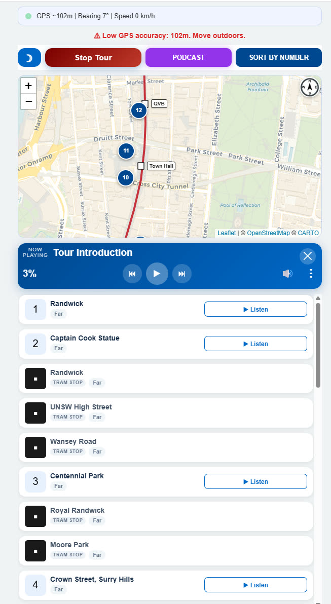
Stops and stories in a single list. Tram stops carry their own marker style and sit inline with the numbered attractions, so a passenger can see at a glance which stop the next story belongs to and where to get off. One button re-sorts everything: by distance — what is nearest right now, re-ordering itself as the vehicle moves — or by number, the line in its proper running order. The GPS strip at the top reports accuracy, bearing and speed, which matters in the CBD: tall buildings degrade the fix, and the engine widens its zones to compensate rather than firing a story in the wrong block. And nobody has to guess what is currently talking: the card of the attraction being narrated lights up — an amber ring and a slight lift — the nearest few carry a brightness gradient behind it, and anything already heard fades back.
Between stops the podcast plays, and the player is what regular riders end up using most. ⏮ and ⏭ step through the episode paragraph by paragraph instead of a blind fifteen seconds, volume and playback speed are one tap away, and nothing has to be found again: the position is remembered, so a passenger who gets off at Central and boards again next Tuesday hears the podcast resume at the exact second it stopped.
The map tracks the vehicle live and holds either orientation — North Up, or Heading Up, where the map turns automatically with the direction of travel, so left on the screen is always the left-hand window.
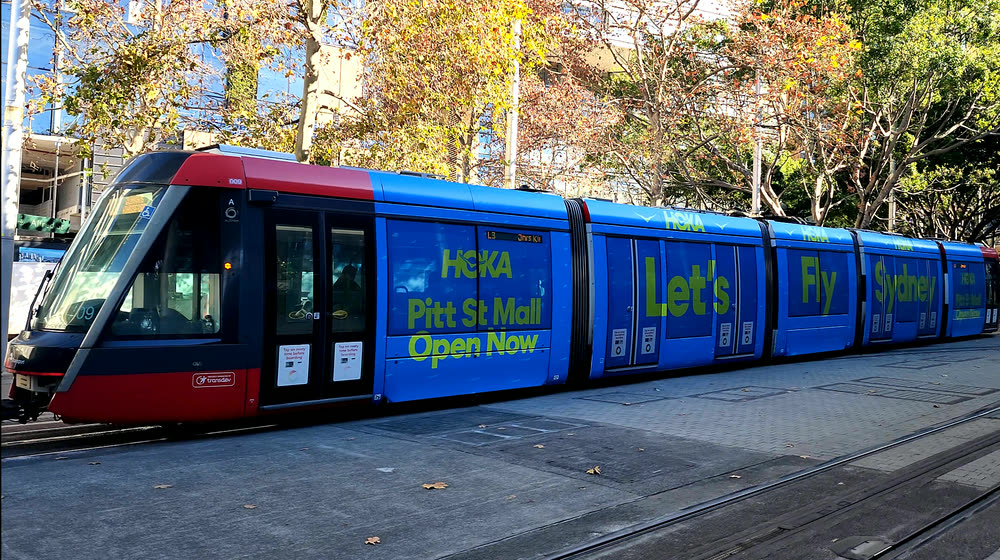 Rolling media, now with a soundtrack. The vehicle already sells its exterior to advertisers. The audio layer adds an inventory the livery cannot reach: a sponsored line delivered at the moment the tram passes the sponsor’s own street, to a passenger who chose to put headphones in. Same vehicle, second revenue surface — and one that reports real plays rather than estimated impressions.
Open the live tram guide
Technology 2 — Festivals & events, on foot
Events — audio that unlocks when you walk into the artwork
Built for festivals, light walks, sculpture trails and precinct events. Each installation gets a trigger zone on the map; walk inside it and the commentary starts by itself — who made it, what it means, what to look for. Visitors keep their eyes on the artwork instead of reading a plaque with a torch.
- Trigger zones drawn per installation — a wide circle for a building-scale projection, a tight one for a small sculpture.
- Navigate button routes the visitor to the next piece; the list re-sorts by distance as they move.
- Night-mode interface by default — readable on a phone in the dark without wrecking night vision.
- Content can be swapped between festival editions in hours, not through an app release cycle.
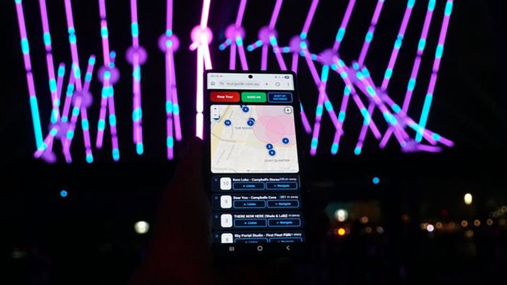 In the field at a light festival. The visitor is standing in front of the artwork with the phone already in their hand — the commentary started by itself the moment they crossed into the zone. Nothing was typed, no number was matched to a plaque, and the screen stays in night mode so it does not blind anyone around them.
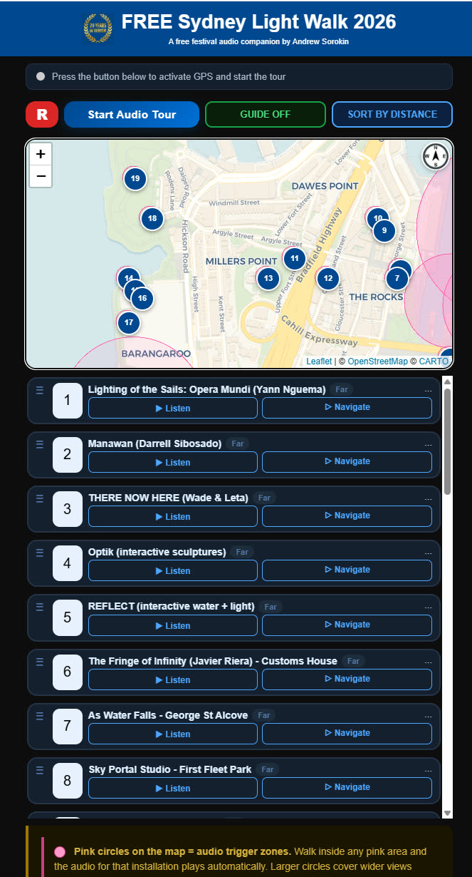
The whole festival mapped as geofences. Each pink circle is an audio trigger zone, sized to its installation — wide for a building-scale projection you can see from three streets away, tight for a sculpture you have to walk up to. The radii are drawn on the map deliberately: the visitor can see where the audio is going to start and step closer, instead of wondering whether the guide is working. Because the zones do the work, the numbering is a suggestion rather than a queue — wander in any order. The card of the installation currently playing lights up in the list while the closest few glow behind it, so in a dark, crowded precinct you can find your place on the screen in a glance instead of reading it.
Nobody has to wait for a trigger either. Listen plays any piece from wherever you are standing, which matters when a queue is long or a lane is closed, and Navigate hands that installation to Google Maps for turn-by-turn walking directions.
The list keeps ordering itself around the visitor: whatever is nearest rises to the top, and anything already heard sinks to the bottom, so what remains up top is what is still ahead of you. The map can stay locked to North or switch to Heading Up and rotate with your direction of travel — in a dark, crowded precinct that is the difference between “it is on your left” and half a minute of turning on the spot. And the guide keeps your place in the audio: stop the podcast mid-sentence, wander off for a coffee or come back the following night, and it resumes from the exact second it was stopped.
Open the live event guide
Technology 3 — Walk, bicycle or car
One guide, three speeds — on foot, on two wheels or at the wheel
Same page, same point database, completely different geometry underneath. The engine measures your real average speed and rebuilds the trigger zones around it. Below 10 km/h it works out which way you are facing and splits the distance between two nearby markers, so a story fires at the right doorway instead of a block early. At road speed it does the opposite — wide, early, decided once — because a driver gets exactly one chance to look.
🚶 On foot and on two wheels
On a bicycle the same route runs with wider, earlier zones, and the group filter carries dedicated bicycle trails so the route follows cycleways rather than footpaths.
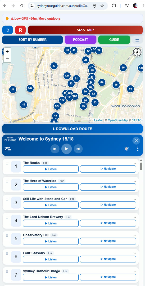
What the walker gets — and the player behind it
- Listen on demand for anything in the list, or leave Guide Mode on and let GPS do it.
- Navigate hands the point to the phone’s map app for turn-by-turn walking directions.
- Download Route exports the whole walk for offline planning.
- The card of whatever is being narrated lights up — amber ring, slight lift — the nearest few glow behind it, and anything already heard fades back.
- The podcast fills every gap between points — and resumes at the exact second on the next outing.
The player itself is the part visitors notice last and miss first. It carries no seek bar — dragging a thin line is hopeless while walking — so ⏮ and ⏭ move by paragraph, using a sentence map generated for every audio file. A skip lands on a full thought, back-skip from the top of an episode rolls into the last paragraph of the one before, and playback speed (1× to 3×), volume and the day-night switch are each a single tap, with menus opening downward so the map is never hidden. Interrupt an attraction halfway and the guide remembers where you were; walk away mid-podcast and it is still there tomorrow.
🚗 At the wheel
The hardest case, and the one the platform was born for. At road speed the guide has to decide early, speak once, and say which window to look through — all without asking the driver to touch anything. It runs on the phone and plays through the car speakers over Bluetooth, so the driver’s hands and eyes stay where the law and common sense want them.
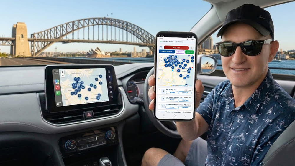 Any car, no integration project. The tour runs on the phone and the audio arrives through the car speakers over Bluetooth — the same pairing every driver already uses for music. Nothing is installed in the vehicle, so a rental fleet can offer it on day one across every model in the yard, and the driver never touches the screen once the tour has started.
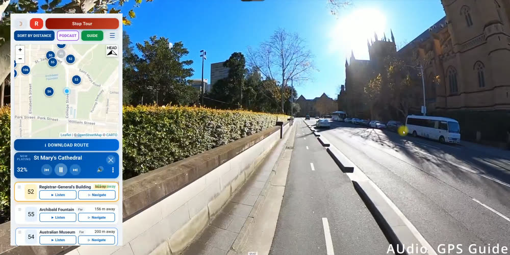 Heading-Up map at road speed. The map is rotated to the direction of travel, so left on the screen is the driver’s actual left. The story fires while St Mary’s Cathedral is still coming into view rather than in the rear-view mirror — that lead time is computed from current speed, not from a fixed radius, which is the difference between a useful cue and an announcement about a building you have already passed.
Open the live guide
See the consumer product
📢 Not only an information system — an advertising channel
Everything the engine already knows in order to tell a story — where the listener is, which way they face, how fast they are moving and what time it is — is exactly what makes an advertising slot valuable. The same trigger that plays a landmark can play a sponsored message, and it can play it at the only moment that matters: while the business is passing the window.
Geofenced audio spots
A restaurant precinct, a shopping centre, a winery on the highway: the insert fires as the vehicle enters the zone and nowhere else. Radius, direction of travel and speed are all conditions you can set.
Sponsored points in the list
A branded card with its own Listen and Navigate buttons sits in the visitor’s route list — a one-tap path from an audio mention to the front door.
Route-level sponsorship
An operator, council or brand can present an entire line or trail: opening credit, closing credit, and a matching QR poster campaign at the stops.
Measured, not estimated
The console counts real sessions, real durations and real positions — so an advertiser is quoted delivered plays inside a zone, not printed circulation.
Editorial discipline: sponsored audio is frequency-capped, kept clearly separate from the guide narration, and never fires while a landmark story is playing. A tour that starts nagging is a tour that gets switched off — which would cost more than the slot is worth.
🔒 A risk-free proposition: full technology escrow
Buying a platform from a specialist team raises one fair question: what happens to our service if that team disappears? The answer is a real, extended technology escrow — a complete working package lodged with an escrow agent, sufficient for any third-party IT team to redeploy the platform from scratch.
1. Technical base
- Platform source code.
- A list of every external service, API and software dependency.
- Full deployment documentation — step-by-step instructions for standing the system up from zero.
2. Content and data
- The points database: all GPS coordinates, trigger radii, direction vectors and text descriptions.
- Studio-quality master audio files, from which the streaming audio can be regenerated.
3. Infrastructure and access
- A mechanism for transferring domain rights, DNS records and SSL certificates — so tourists never have to find a new address or download anything new.
Release conditions (triggers)
The buyer has no access to these materials in normal operation — they sit in the escrow agent’s safe. The package is opened and handed over only on a critical event:
- Our company declares bankruptcy or liquidation.
- The service is unavailable — servers down, for example — for more than 30 consecutive days.
- A critical breach of the SLA occurs and is not remedied.
Under the hood: .NET, JavaScript, and scaling that is a setting rather than a rewrite
A procurement question we get early: what happens when it works too well? A festival opening night, a cruise ship arrival, a stadium crowd — all reaching for the same link in the same ten minutes.
🖥 Server: ASP.NET
The pages, the access-token layer, the session logging and the audio streaming handler are .NET. Audio is delivered with proper HTTP range support (206 responses), which is what makes seeking, resuming and paragraph skipping work on mobile networks instead of forcing a full re-download every time somebody moves the playhead.
💻 Client: plain JavaScript
The whole guide — GPS loop, trigger geometry, bearing maths, map, player, interest filtering — runs in the visitor’s browser in vanilla JavaScript. No framework to go out of support, no app binary to rebuild and resubmit, and no client-side dependency that a government network is likely to block.
☁ Azure-ready autoscaling
The stack deploys to Microsoft Azure App Service without a rewrite, with autoscale rules on instance count and a CDN in front of the audio. Capacity becomes a configuration value: you raise the ceiling before opening night and lower it on Monday, and nobody touches the code.
📈 Why it scales at all
Because the guide holds no per-listener state on the server. Position, progress and playback all live in the visitor’s own browser; the server hands out static audio and records sessions. That is the architectural reason a crowd of half a million streaming simultaneously is an infrastructure setting rather than an engineering limit — there is no shared bottleneck for concurrency to collide with.
Want it running on your line, your festival or your fleet?
All three technologies above are live in Sydney today — open any of them on your phone right now and walk outside. If you operate transport, run an event, rent cars or manage a destination, the same engine can carry your route, your voice and your sponsors.
Email [email protected]
WhatsApp +61 405 808 717
Antratel Pty Ltd (ABN 24 122 328 492), trading as Sydney Private Guided Tours — licensed Sydney guides since 2006.
×
![]()
|